OR DO THE SEARCH YOURSELF , --- more pictures below !
to confirm for yourself ,
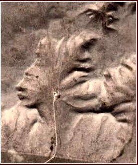
1. go to http://maps.google.com/
2. search th co-ordinates .. 50° 0'38.20"N 110° 6'48.32"W
3. click satellite
4. and look at the 3rd , 4th, 5th, 6th zoom bar from the top
original email from anthony oberstaller, anthony@ccountry.net
original email from anthony oberstaller, anthony@ccountry.net
1 comment:
This fine picture is an optical coincidence, its really a depression in a high flat ridge, there is an approach road to a well site that is at the base of the "ear lobe" Also important is the height of the sun at the time of the day that results in the shadows that cause the image to appear. In the noon day sun a different picture would appear, Been to the place its just North of the TransCanada Highway to the east of Walsh Alberta in Canada. Its just a vaqlley in a cattle pastures.
Roger Nelson
www.shrinesandsacredsites.com
Post a Comment